Digital Twins: A New Tool for Emergency Management in Western Australia
The Challenge
Western Australia faces a reality where bushfires and extreme weather events are becoming more frequent, more intense, and more unpredictable. As these pressures grow, so too does the need for smarter, faster, and more coordinated decision making across government. Technology alone won’t solve the challenge, but it can improve how we understand risk, prepare for emergencies and support our communities through recovery making across government.
Department of Fire and Emergency Services (DFES) is leading one of Spatial WA’s four pilot use cases to do just that, demonstrating how digital twin capability can support planning, preparedness, response, and recovery for bushfire and multi hazard scenarios.
The opportunity
Through Spatial WA, the WA Government is building a statewide digital twin, a dynamic 4D view of our real world. This isn’t just a mapping tool, it’s a living, connected representation of WA’s built and natural environment, enriched with demographic, social, and environmental data to strengthen our decision-making before, during and after and emergency event applied anywhere in the State.
Before an Emergency Event
For example, planners need the ability to better allocate resources and plan for new fire stations based on population growth and need, as well as map out service routes in 3D leveraging traffic and road data. Using the Digital Twin collaboration capability, teams will be able to undertake consultative planning as well as assessing new planning and subdivision applications for bushfire risk and review bushfire management plans.
Preparedness and Response
Advanced tools such as 3D modelling and simulation will allow DFES teams to model fire spread or flood extent based on different scenarios and weather data. Whilst this work already happens it is often in 2D and done by specialists. By leveraging the Digital Twin, it will make it easier, more powerful with 3D visualisation and more accessible.
As a cross-government collaboration platform DFES will be able share these 3D visualisations within the Digital Twin to other agencies and Local Government on the ground. This will help provide a shared understanding and collaboration space to add notes and capture local insight.
The benefit has many potential uses such as being able to export 3D flythroughs and visualisations along with high resolution interactive maps to assist with local training and preparedness exercises.
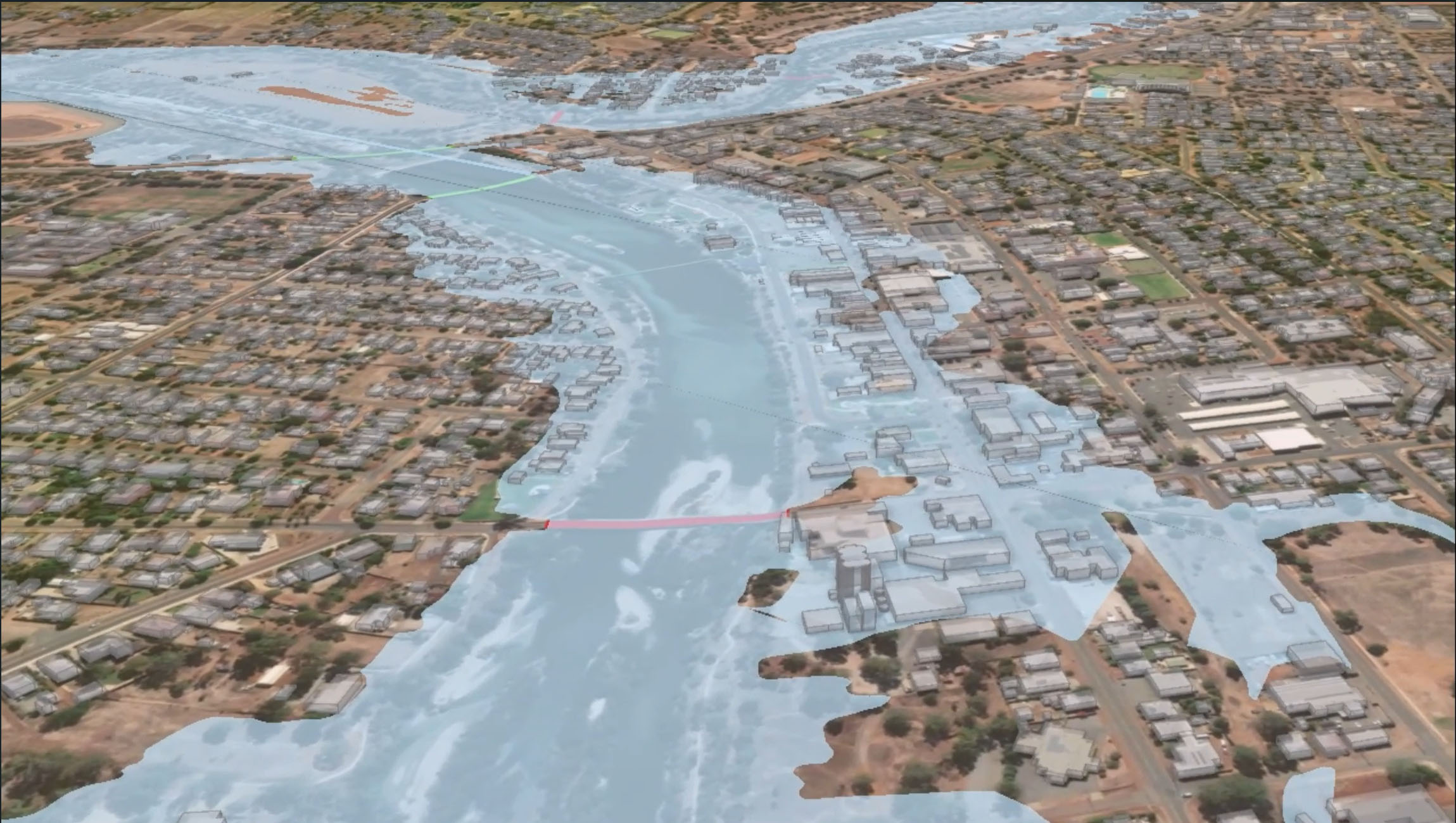
3D Flood modelling can help communities plan for emergencies before they happen.
Recovery
Some of the most powerful benefits emerge after the immediate danger has passed. Recovery teams can use the Digital Twin to assess community needs holistically combining aerial imagery, building information, demographic data, and service availability to understand what kind of support is most needed and where it should go. For example identifying land or buildings suitable for emergency accommodation or mobilising health units. Responders on the ground can capture and upload imagery of damage into the twin for that back behind the desk to assess impact faster, more accurately estimate the cost and better plan for the rebuilding of infrastructure and communities. Over time, progress on recovery can be visualised to help track rebuilding and report back to government with confidence.
The Challenge
The challenge for the team over the next two years is not simply technical. Delivering the use case at scale requires strong governance, trusted data, and sustained collaboration across agencies, Local Government and the private sector.
By embedding digital twin capability into planning, preparedness, response and recovery, DFES and Spatial WA are laying the foundations for a more connected approach to emergency management in Western Australia.
Digital Twins are not a silver bullet, yet the State’s Digital Twin will provide a powerful new tool in WA’s emergency management toolkit - one that supports smarter decisions today and builds resilience for the future.
-
 Program Update: February 2026
26 February 2026
Program Update: February 2026
26 February 2026
-
 Debunking Digital Transformation Myths
26 February 2026
Debunking Digital Transformation Myths
26 February 2026
-
 NSW Digital Twin: Delivering more value and expanding use cases
A case study on the NSW Digital Twin and new use cases
3 November 2025
NSW Digital Twin: Delivering more value and expanding use cases
A case study on the NSW Digital Twin and new use cases
3 November 2025